
Sage Stomp XXXVII Kamloops
May 21st 2022 9:00am - May 22nd 2022 2:00pm
Organizers: Brian May (Event Director), Alan Vyse (Permit), Phil Wallensteen (Course Planner), Keeya Corbett (Course Planner), Alan Corbett (Course Planner), David Bakker (Course Planner), Wade Tokarek (Controller)
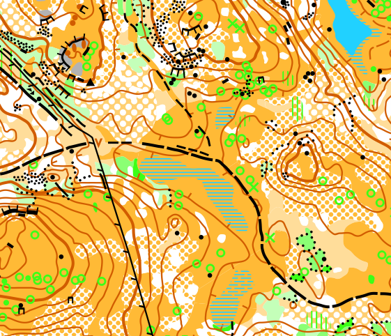
Map: Gardens Creek
- Now posted for all events - 3DReRuns coming later once GPS tracks have been uploaded.
3D-ReRuns
Middle
Long
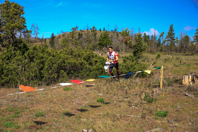
The 37th annual Sage Stomp is back to its traditional May long weekend and its traditional location - Sage grasslands near Kamloops. This year we are on the Gardens Creek map. A big Thank You to the Gardens Creek Ranch for allowing us access.
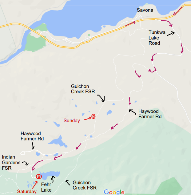
Location/Directions
The event site is near Savona, about 40 minutes west of Kamloops.
* From Kamloops, follow Hwy 1 West (toward Cache Creek).
* In Savona, turn left (south) off Hwy 1 onto Tunkwa Lake Road for 4 km.
* Turn right (west) on Haywood Farmer Road for 5 km.
* Then follow O signs.
* Saturday – Continue West to Fehr Lake
* Sunday – Turn North onto Guichon Creek FSR
Saturday AM - Training/Instruction
Check-In at 9:00 am. Training/Instruction at 9:30 am. Course closes at 11:00 am.
- Experienced Orienteers: A solo training opportunity - 4.1 km course with three different types of training exercises included.
- Beginner and Intermediate Orienteers: Small-group coached session working our way around appropriate courses. [Same course (with options to short-cut).]
- Organization Team:
- Course Planner: David Bakker
- Map: Gardens Creek, 2007, Bryan Chubb, ISOM2000, 1:7500, 5 m contours.
Parking Location: https://www.google.ca/maps/place/50.707174,-120.868468
Saturday PM - Middle-Distance
First Start at 12:00 pm. Last Start at 1:00 pm. Course closes at 3:00 pm.
- Organization Team:
- Course Planner: Phil Wallensteen
- Controller: David Bakker
- Map: Gardens Creek, 2007, Bryan Chubb, ISOM2000, 5 m contours.
- Walk to Start: 100 m to the North end of the Parking area
|
Course |
Beginner |
Intermediate |
Advanced |
Expert |
Elite |
|
Distance |
2.3 km |
3.0 km |
2.9 km |
4.5 km |
5.5 km |
|
Climb |
25 m |
90 m |
115 m |
195 m |
250 m |
|
Scale |
1:7500 |
1:7500 |
1:7500 |
1:10000 |
1:10000 |
Advanced/Expert/Elite all feature technically difficult navigation.
Parking Location: https://www.google.ca/maps/place/50.707174,-120.868468
Sunday AM - Long-Distance
First Start at 9:00 am. Last Start at 10:00 am. Course closes at 1:00 pm.
- Planning Team
- Course Planner: Alan Corbett and Keeya Corbett
- Controller: Wade Tokarek
- Map: Gardens Creek, 2007, Bryan Chubb, ISOM2000, 1:7500, 5 m contours.
- Walk to Start: 500 m North along Guichon Creek FSR
Course | Beginner | Intermediate | Advanced | Expert | Elite |
Distance | 2.8 km | 3.7 km | 4.3 km | 6.6 km | 9.5 km |
Climb | 75 m | 175 m | 205 m | 410 m | 620 m |
Scale | 1:7500 | 1:7500 | 1:7500 | 1:10000 | 1:10000 or 1:15000 |
Advanced/Expert/Elite all feature technically difficult navigation. Participants on the Elite course can choose a map scale of 1:10000 or 1:15000 at the Start.
Parking Location: https://www.google.ca/maps/place/50.728028,-120.836361
Terrain
The terrain comprises a mix of grassland, semi-open and forested areas. There are numerous rocky features (boulders and cliffs). The terrain is generally quite dry. Small marshes and lakes dot the terrain (depending on the weather, they may be drier than shown on the map). The map is generally quite reliable (contours, rock, trails). However, distinct trees (green circles and green x's) have not been re-mapped in several years and should not be counted upon. You may need to cross fences in the terrain - it is preferred to go under the fence so that you do not damage it while passing.
New Orienteers
Our event is beginner friendly. The instruction on Saturday morning is targeted to new orienteers. Each event will have a Beginner course suitable for new orienteers. We look forward to meeting you!
Registration
Registration is now closed. You can check the confirmation list on Zone4.
Costs
Entire Weekend
- Adult (Born in 2001 and earlier): $45
- Junior (Born in 2002 and later): $25
Single Day
- Adult (Born in 2001 and earlier): $25
- Junior (Born in 2002 and later): $15
Event Timing
Timing will be done with the SI Air timing system. SI Air cards will be available to all registrants as part of your registration fee, with a small discount available to individuals bringing their own SI Air card. Participants are also encouraged to carry a GPS so that we can set up a 3D Re-Run for each course. Start times will not be assigned (we will spread out competitors on each course). Split starts will be available for parents of small children (contact the event director to arrange). Live Results will be available online during the event (use the link above).
SI-Air:: Use the "Check" box before the start to turn on your SI-Air stick. The Start, Controls and Finish are all active in Air mode. The "Finish" box turns off your SI-Air stick. If a control doesn't work in Air mode, punch the normal way. More details at https://docs.sportident.com/datasheets/en/datasheets/sportident_airplus_information_for_athletes.html
Volunteer
Please consider volunteering to help out at the event (before or after your run). Available volunteer opportunities are posted here ... https://signup.com/go/ahjnSNR.
Awards
For each event (Middle-Distance and Long-Distance), the top male and female competitors on each course will be recognized with a modest award.
Accommodation
Savona has very limited services.
Kamloops has a variety of hotels and motels http://www.tourismkamloops.com/
Camping is available (non-reservable) at Steelhead Provincial Par
Camping is NOT permitted on the map.
Food
Due to COVID, very limited refreshments will be offered at the finish. You are encouraged to have food and water at your car. Porta-potties will be available.
Water will not be supplied on course - you should carry your own water, especially if it is hot.
Safety Info
- Cell Coverage: All events occur in areas with cell coverage. There may be local zones on course without coverage.
- Fire Safety: We will cancel the event or turn it into a training (not competition) only if (a) the air quality is hazardous for humans and/or (b) there is a major risk from a nearby fire (not likely in May).
- Wildlife: Cattle will be grazing in the area – please give them a wide berth to avoid unnecessary disruption. There may be bears in the area, carry bear spray if you wish. Ticks have been observed in the area this spring. The north part of the map has numerous cacti - be careful where you step.
- COVID Safety: Most Covid-related restrictions have now been lifted in BC (see BC Province-side restrictions). All sporting activities are now allowed (see viaSport BC). That said, we do encourage limiting close contact with others. Please wear a mask when social distancing is not possible. Be kind and respectful of others.
- Travel Restrictions: Our friends from the United States are very welcome to join our event. You are encouraged to check the travel restrictions in place (see Canada Covid-19: Travel, testing and borders) in order to smoothly cross the border to/from Canada.
Check yourself for ticks after you have been in the forest.
Contact
Questions? Feel free and send the event director Brian May an email at contact AT SageOrienteering.ca