
Larch Hills Adventure Run Salmon Arm Weekends
June 17th 2018 10:00am

Map: Larch Hills
Results:
Results are now posted here. Apologies to Jude who's time somehow got lost, and to a few others on the 2 hour course who don't have intermediate splits posted for their course although their punches for correct. Thanks to everyone for coming out, next event is tomorrow in Pileated Woods in Salmon Arm!
How It Works:
Basically, it's a tiny Barkley Marathon. Instead of a fully marked course telling you exactly where to go, there are 30 plus checkpoints scattered around the hill (both on and a few off trail). Your job is to choose the best way to link as
many of them together as possible, pick and navigate your route between
each one, and get back to the finish before time runs out.
Course Options:
- 1 Hour Adventure Run (you have one hour to get as many as you can).
- 2 Hour Adventure Run (you have two hours to get as many as you can).
- 3 Hour Adventure Run (We're guessing you can figure out how many hours you have to get as many as you can).

A Checkpoint Marker - Each Checkpoint will be Marked by a Similar Orange and White Bag and an Electronic Time Keeping Device.
Teams:
You can register as:
- An Individual
- A team (2-4 people)
Registration Costs:
Sage Orienteering Club Members:
- Individual - $10
- Team - $10/Team Member
Non Members
- Individual - $15
- Team - $15/Team Member
Limited on the day registration is available for an additional $5 surcharge per person.
Family Maximum cost of $25/family.
How To Register:
Registration is now open, click the green "+ Register" button next to your desired course and follow the instructions. No online payment, cash or cheque accepted on the day at the event site.
Race Day Schedule:
- 9:30 - Mandatory Race Instructions
- 9:45 - Maps Handed Out (begin planning your route now!)
- 10:00 - Race Begins
- 11:00 - One Hour Race Finish
- 12:00 - Two Hour Race Finish
- 1:00 - Three Hour Race Finish
- 1:15 - Results and Awards
Scoring:
Depending on how far the checkpoint is from the start and how difficult it is to find it is worth a different amount of points. The most challenging checkpoints are worth 120 points, intermediate difficulty checkpoints are 80 points, and the closest and easiest are worth 40.
For each minute that you or your team is back late, a penalty of 10 points deducted from your total score.
Results:
Results are based off:
- Your total number of points (including time penalty deductions)
- And in the event of a tie in the number of points, the finish time.
Event Timing:
SI (SportIdent) electronic timing will be used for this event. If you have your own e-punch, please bring it; otherwise they are available to borrow at the event.
The Map:
We will provide you with a detailed contour map with 5 meter contours, trails, water features (creeks, ponds, marshes and lakes), and computer generated vegetation density. It will have all the checkpoints clearly marked on it. It is everything you need to complete the course.
This said, all navigational aids are fair game. A compass will be beneficial (the map is oriented to magnetic north, no declination needed). If you think using a GPS will help you, go right ahead, if you think using a drone will help you (we don't think it will, but please send us the footage if you do), go for it! Clever individuals may make use of the "You Are Here" arrows on the ski trail maps posted at many intersections.
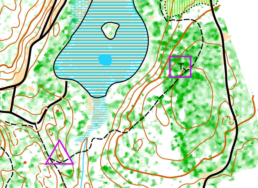
A Small Sample of the Provided Map
Start/Finish Location:
Larch Hills Chalet.
Safety:
For added safety, WHISTLES ARE MANDATORY. You can bring your own whistle or buy one at the event for $1.
Carrying bear spray is recommended, but not obligatory.
We also recommend you carry some water with you, but there will be 2 points out on course at which you can get water as well as the start/finish.