
BCOC & WCOC 2026
September 19th 2026 9:00am - September 20th 2026 2:30pm
Organizers: David Bakker (Course Planner), Phil Wallensteen (Course Planner), Kevin Matrosovs (Assistant), John Rance (Controller), Brian May (Event Director)
Map: Westwold South
Thanks for Coming!
A big THANK YOU to all who came to the BCOC and WCOC 2026. We had lots of positive feedback and we really hope you enjoyed your weekend of orienteering. The weather was fantastic and we were super pleased to show off two new and very unique venues. Super-fun running and challenging terrain!
And, Thanks again to all the volunteers who made the weekend possible.
Results
Finish Placing
Now updated with BCOC/WCOC eligibility
Split Results
Livelox
Check out GPS tracks from other athletes, and upload your own!
Start Lists
- Middle: Middle-by-Class.pdf
- Long: Long-by-Class.pdf
Please let us know if any thing is amiss!
Overview
Welcome to the 50th BC Orienteering Championships and the Western Canadian Orienteering Championships!
We are excited to feature two brand new maps in the Shuswap:
- Saturday Middle Distance near Westwold, BC.
- Sunday Long Distance near Enderby, BC.
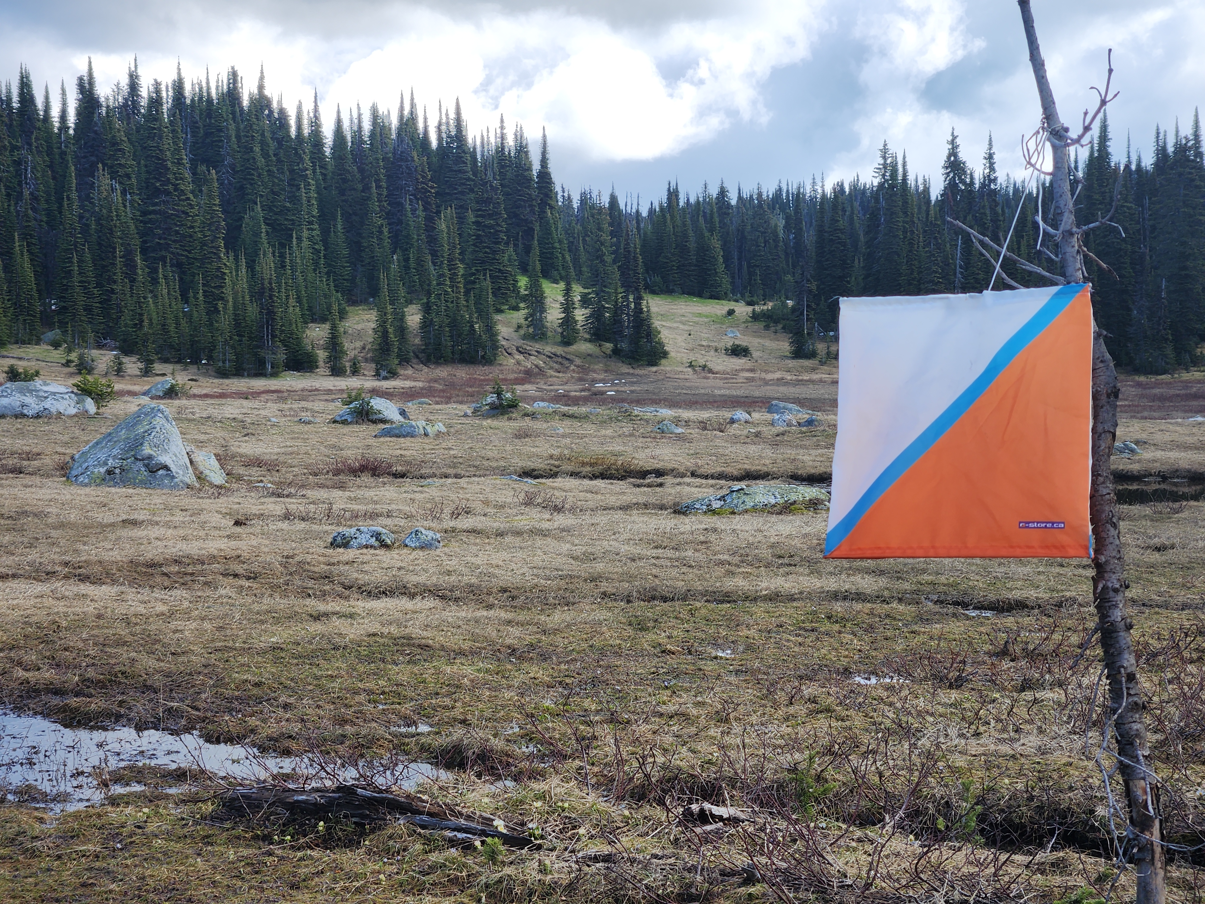
Check-In / Package Pick-Up
- Maps for the Model event will be available at 9:00 AM Saturday at the Model event parking.
- Check-in for the Middle and Long will be available at 10:00 AM Saturday at the Middle-Distance Arena.
- Check-in for the Long will be available at 9:00 AM Sunday at the Long-Distance Arena.
Included in the package are bibs and borrowed SI sticks (which must be returned at the Finish of your last event).
Training: Friday to Sunday (Anytime)
- Self-directed training on the Dirty Beetle map near Glenemma, BC.
Parking Location: https://maps.app.goo.gl/z8y14WmyTwRBbkmn9 - Two courses: Intermediate & Advanced
Two scales: 1:7500 and 1:10000 - Print your own PDF map.
Link to Download: https://nextcloud.sageorienteering.ca/index.php/s/QfSnokfTsC5awij - Controls are marked with orange and white ribbon (placed on Sep 12).
Note that the courses will not be checked again, so there is possibility of some ribbons going "missing".
Model: Saturday Morning
Location
- Westwold, BC
Schedule
- 9:00 AM Onward
Organizing Team
- Course Planner: Phil Wallensteen
Map
- Mapper: Phil Wallensteen, David Bakker (2026)
- Specification: ISOM 2017-2
- Scale: 1:7500 or 1:10000
- Contours: 5 m
- Basemap: LiDAR
Course Details
- Control flags (no punches or SI)
- Do controls in any order
- Map is representative of the Middle distance terrain
- Terrain is similar (but steeper)
Parking
- Pinaus Lake Road (Ingram FSR), Westwold BC
Location: https://maps.app.goo.gl/YEDEysw9Ung4mBkc7 - Signs from the junction of Hwy 97 and Pinaus Lake Road
Go 1.5 km on Pinaus Lake Road (Ingram FSR)
Maps & Start
- Maps available at 9:00 AM
- Look for a sign & bin near the parking location
- Select the map scale appropriate to your Middle event
- Start location is very near by
Middle: Saturday Afternoon
Location
- Westwold, BC
Schedule
- 12:00 PM to 3:30 PM
Organizing Team
- Course Planner: Phil Wallensteen
- Controller: John Rance
Map
- Mapper: Phil Wallensteen, Brian May, and David Bakker (2026)
- Specification: ISOM 2017-2
- Contours: 5m
- Basemap: LiDAR
Brand new map features open runnable forest with numerous small clearings and contour detail. Map slopes from south to north, but there are a number of hills, depressions and other features to break up the terrain. Very few rock and water features. Expect fast running as long as you maintain contact with the map.
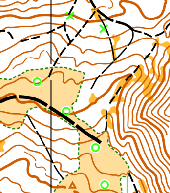
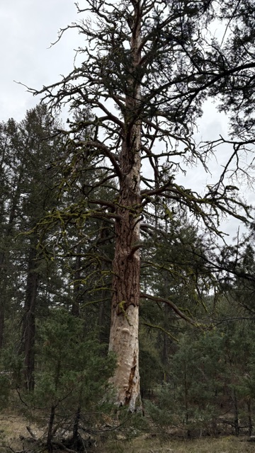
Special features ...
 Prominent live tree (in open terrain).
 Prominent dead tree (usually within forest, see photo below).
 Slash pile (in open terrain).
Course Details
This is a Canada Cup with Championship classes, as well as open classes on all courses. Course information:
|
Course |
TD |
Age Classes* (Female) |
Age Classes* (Male) |
Open |
Length (km) |
Climb (m) |
Scale |
|
1 |
1 |
F10- |
M10- |
Open 1 |
1.9 |
75 |
1:7500 |
|
2 |
2 |
F12- |
M12- |
Open 2 |
1.9 |
80 |
1:7500 |
|
3 |
3 |
F14- |
M14- |
Open 3 |
2.5 |
110 |
1:7500 |
|
4 |
3 |
F16- |
M16- |
Open 4 |
2.7 |
135 |
1:10000 |
|
5 |
4 |
F75+ F80+ F85+ F90+ |
M80+ M85+ M90+ |
Open 5 |
2.4 |
110 |
1:7500 |
|
5S |
4 |
By request. |
By request. |
2.2 |
75 |
1:7500 |
|
|
6a |
5 |
F65+ |
M65+ M75+ |
3.0 |
165 |
1:7500 |
|
|
6b |
5 |
F18- F45+ F55+ |
Open 6 |
3.0 |
165 |
1:10000 |
|
|
7 |
5 |
F20- F21-34 F35+ |
M18- M45+ M55+ |
Open 7 |
3.9 |
195 |
1:10000 |
|
8 |
5 |
M20- M21-34 M35+ |
Open 8 |
4.5 |
200 |
1:10000 |
* Age as of Dec 31, 2026. "F14-" means "Female 14 and younger". "M45+" means "Male 45 and older"
* 6a/6b are identical other than map scale
* A short version of course 5 is available by request.
Parking & Arena
- Pinaus Lake Road (Ingram FSR) Westwold, BC
Location: https://maps.app.goo.gl/6Ppizcgu3kNX3B9Z8 - Signed from the junction of Hwy 97 and Pinaus Lake Road
Go 3 km on Pinaus Lake Road (Ingram FSR) - Park as directed along the road. Short walk (< 200 m) to Arena
- Toilets are available at the Arena
Arena to Start
- Follow pink pin flags (up the road from the Arena)
- 300 m walk with 25 m climb
Water:
- There is no water available at the start
- There is no water available on course
Maximum Time on Course:
- 2 Hours
Long: Sunday
Location
- Hunter's Range, near Enderby, BC
Schedule
- 10:00 AM to 2:30 PM
Organizing Team
- Course Planner: David Bakker
- Controller: Teresa Winn
Map
- Mapper: David Bakker (2026)
- Specification: ISOM2017-2
- Contours: 5m
- Basemap: LiDAR
Brand new map features a stunning alpine paradise of meadows, open and light green forest, creeks, marshes, and rolling contours. There is a scattering of rock across the whole map and only a few trails. Situated around 1900 m in elevation, the Monashee Mountains are in the distance, but you'll be focused up close on the spectacular visual and technical beauty of this sub-alpine orienteering paradise.
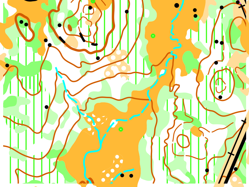
The south portion of the map (near the end of the courses) features an area of recent re-growth with trees that are smaller and more spread than elsewhere on the map. Despite feeling somewhat "open", the mapper has predominantly used white to show this forest. Rough open (with or without scattered trees) has been used sparingly in this section of the map.
Course Details
This is a Canada Cup with Championship classes, as well as open classes on all courses. Course information:
Course | TD | Age Classes* (Female) | Age Classes* (Male) | Open | Length (km) | Climb (m) | Scale |
1 | 1 | F10- | M10- | Open 1 | 1.8 | 20 | 1:7500 |
2 | 2 | F12- | M12- | Open 2 | 2.7 | 35 | 1:7500 |
3 | 3 | F14- | M14- | Open 3 | 3.4 | 45 | 1:10000 |
4 | 3 | F16- | M16- | Open 4 | 4.6 | 85 | 1:10000 |
5 | 4 | F75+ F80+ F85+ F90+ | M80+ M85+ M90+ | Open 5 | 3.4 | 50 | 1:7500 |
5S | 4 | By Request | By Request | 2.4 | 50 | 1:7500 | |
6a | 5 | F65+ | M65+ M75+ | 4.9 | 100 | 1:7500 | |
6b | 5 | F18- F45+ F55+ | Open 6 | 4.9 | 100 | 1:10000 | |
7a | 5 | F35+ | M18- M45+ M55+ | Open 7 | 8.1 | 195 | 1:10000 |
7b | 5 | F20- F21-34 | 8.1 | 195 | 1:15000 | ||
8a | 5 | M35+ | Open 8 | 10.2 | 270 | 1:10000 | |
8b | 5 | M20- M21-34 | 10.2 | 270 | 1:15000 |
* Age as of Dec 31, 2026. "M14-" means "Male 14 and younger". "F45+" means "Female 45 and older"
* 6a/6b, 7a/7b and 8a/8b are identical other than map scale
* A short version of course 5 is available by request.
Parking & Arena
- The venue is roughly 20km up the Ashton Creek FSR from Enderby Mabel Lake Road (east of Enderby).
Location: https://maps.app.goo.gl/jwwrgsUpotaa3G9y6
- From Enderby, proceed East on Cliff Ave (which becomes Enderby Mabel Lake Road)
Proceed 6.5 km to Watershed Road - Route is signed from the junction of Enderby Mabel Lake Road and Watershed Road
Follow Watershed Road for 1 km (stay right as pavement turns to dirt)
At the sign for Ashton Creek FSR, set your odometer to 0 km
At 1.0 km, TURN RIGHT onto "Ashton Trail"
At 13.1 km, GO STRAIGHT
At 16.7 km, GO STRAIGHT
At 17.9 km, STAY RIGHT
At 19.5 km, GO STRAIGHT
At 20 km, Park as directed - The forest service road is in good condition but there are a few short sections that are steep and loose. AWD and 4WD vehicles should make it to the parking lot without issue. 2WD vehicles should be ok, with a bit of extra oomph on the steeper sections. That said, 2WD drivers may prefer to carpool to the event.
- Arena is a short walk (300 m) from Parking.
- Toilets are available at Parking.
Arena to Start
- Follow pink pin flags (and orange flagging tape) from the Arena (starting at the last control)
- Route is easy initially, but climbs steeply toward the end.
- 900 m walk with 60 m climb
- There will be no clothing return from the Start to Arena.
Water:
- There is water available at the start (roughly 250 mL per participant)
- There is water available on all courses (roughly 250 mL per participant at each water stop/control)
Maximum Time on Course:
- 3 Hours
Repeated Controls
- Course 2 has a repeated leg. On the map, it looks (very much) like this ...

The route from 6 to 7 is flagged. After doing 8-9-10, the flagged route is repeated (as 11 to 12).
Make sure you do the top "loop" in the correct order (counter-clockwise). - Courses 7 and 8 have a repeated control. On the map, it looks (vaguely) like this ...

Make sure you do the "loop" in the correct order.
Logistics
Punching & Time-Keeping
SI punching and time-keeping will be used for all events. SI Air is enabled on each control. The SI card number that you provided with your registration has been entered into the computer system and appears on your bib. All borrowed SI sticks must be returned at the Finish download table at your last event. If you fail to return your borrowed SI stick, you must pay the fee for lost SI sticks.
Each control is equipped with a control flag and an SI electronic control unit. The control code is located on top of the SI unit.
Bibs
Competitors are assigned one bib for all events which can be picked up at the Registration table at the Event Arena. Each bib will contain the competitor's name, SI number, course and assigned start time. All competitors must wear their bibs on their shirt front during all competitions. Competitors are encouraged to bring their own safety pins.
Start Lists
Start lists will be available on this webpage and at each Event Arena and Start. Start times are drawn randomly within each class. Organizers may take into consideration requests for early or late starts.
Start Procedure
- Cross each line in the start grid as follows:
Start time -3 min: Name and SI # Check
Start time -2 min: Loose control descriptions available
Start time -1 min: Proceed to map
Start time -0 min: Punch start punch and begin your Race - Start triangle is 50 to 70 m from the start punch
You must follow the marked route to the start triangle
You must pass the start triangle flag but no punch is required.
Finish Chute
- Follow blue pin flags
Jury
- Brian Ellis (BC)
- Charlotte MacNaughton (AB)
- Pia Blake (YT) / Tim McLaren (AB)
Emergencies & Hazards
Emergency Contact
The Event Director’s mobile number is 250-253-8746 and is printed on each course map. Emergency Response will be engaged by the Event Director or another event official as necessary.
911 is the Canadian emergency number for ambulance, fire and the Royal Canadian Mounted Police (RCMP). Contact the Event Director or go to the registration table at the Event Arena before you contact 911 from an event site. Ideally, have an event official call so that they can provide directions.
Nearby Medical Facilities
Saturday:
Royal Inland Hospital
311 Columbia St, Kamloops, BC V2C 2T1
Sunday:
Shuswap Lake General Hospital
601 10 St NE, Salmon Arm, BC V1E 4A7
Animals
The event terrain could contain wildlife such as deer, moose, cougars and bears. Carrying bear spray is a valid option according to your comfort level. Those unfamiliar with bear encounters may wish to read the following page from the Government of Canada: Safe travel in bear country.
Cows are very likely to be in the competition area. Please try not to chase or disturb them more than necessary.
Weather
The weather forecast for this weekend is looking quite promising, with Sun and Mix of Sun and Cloud.
The Saturday event is at low elevation (750 m) and no particular weather concerns are anticipated. The Sunday event is in sub-alpine terrain at much higher elevation (1850 m). Expect the temperature to be up to 10 degrees colder than in the valley! Competitors should bring clothing to accommodate a wide range of temperatures and weather conditions.
Food
We will provide a limited amount of water and snacks after each event. Otherwise, there will be no food service at or near either event site. Please come well prepared with your own food, water, sport drink, etc.
Competitor Risk & Responsibility
All competitors must have signed the waiver before they participate. Everyone who registered online will have done this.
Please bring your own basic first aid kit and sports tape. Open fires and smoking are prohibited at the event site.
Every competitor must carry a whistle while on course. Whistles will be for sale at the registration desk at the Event Arena for $2.00 cash. The recognized distress signal is a series of three short blasts on a whistle. Use your whistle if you need urgent help because of an injury or distress. Pause and listen for reply and repeat to allow helpers to locate you. If you are injured, but still mobile, an alternative might be to make your way to the nearest control so that it is easier to locate you. Competitors are expected to render assistance to anyone who is injured, has blown their whistle, and requires physical assistance. Please give help as needed, and make event officials aware of the issue.
All maps/control descriptions have a “safety bearing” printed on them. In the event of becoming lost, head in that direction, ideally to a major trail, road or the Event Arena.
To avoid initiating unnecessary searches, competitors MUST download at the Finish download station even if they do not complete their course.
In the event of an emergency, competitors are required to follow the directions of the Event Director or Emergency Response personnel.
Clothing & Shoes
There is no regulation requiring specific clothing, but full leg cover is recommended for all events. Standard forest orienteering shoes, with or without metal tipped studs, as per personal preference, are recommended. Grippy trail shoes are another option. Eye protection is a personal choice but is recommended. While there is very little deadfall, the pine trees have small dead branches at eye level and are often fairly close together.
Dogs
Dogs are not allowed on course. If in the Arena area, they must be leashed and under control.
Registration
Registration closes on September 15 at 11:30 PM PDT. Fees go up on September 11 at 11:30 PM PDT.
Fees:
There is a fee per Middle and Long event. The Training and Model events are included at no extra charge.
|
Age Category |
Standard Fee per Event (Middle, Long) |
Late Fee per Event (Middle, Long) |
|
Adult (21+) |
$40 |
$60 |
|
Junior (6-20) |
$20 |
$30 |
Local Information
Getting Here
The events are near the communities of Westwold, BC (Saturday) and Enderby, BC (Sunday). The nearest airport is Kelowna International Airport (YLW).
Accommodation
No specific accommodation has been arranged for the event.
Hotels are available in Vernon and Salmon Arm. More limited options may be available in Falkland, Enderby and Armstrong. A number of campgrounds can also be found in the area. Riverside RV Park and Campground in Enderby is a reasonably central location and appears to be a good option.
In BC, individuals are permitted to camp on Crown land for a period of up to 14 days. Needless to say, you should practice "leave no trace" principles and leave the site in equal or better condition than you found it. Camping is not permitted at either Event site or within the competition area.
Transportation
Public transit does not service the event sites, so transportation by private vehicle is a must.